Compatibility of North Dakota Soils for Irrigation (AE1637, Revised May 2018)
Availability: Web only
Examples of soil degradation and land abandonment due to improper irrigation exist throughout history. When irrigation acreage expands to new areas, determining soil and water compatibility is critical for sustaining yields at high levels.
How to Use This Information
This publication is intended as a first step to help current and prospective irrigators understand the principles behind the irrigability of soils in North Dakota. This publication should be used in combination with soil survey information for the land to be irrigated.
Soil surveys of every county in North Dakota have been completed and documented. Many counties have printed copies, but official, up-to-date soil survey information can be found only on the internet at http://websoilsurvey.nrcs.usda.gov/. Your local Natural Resources Conservation Service office or county office of NDSU Extension can help you obtain soil survey information for the fields of interest.
Understanding the irrigability of the soil in a field begins with knowledge of the local soil series and the way they are represented on the soil survey map. When soil boundaries are drawn on soil maps, the soil-mapping unit is not purely one soil.
The other soils present are of lesser extent and are called minor components. These minor components need to be considered when making irrigation management decisions.
Each soil description may have different phases of slope and other properties that modify its suitability for irrigation. We highly recommend you consult with a qualified soil scientist before making the decision to irrigate.
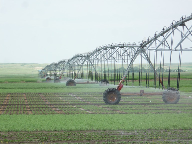
The photo on the cover is of a lateral-move irrigation system (sometimes called a linear-move system) at the Nesson Valley Irrigation Research Site. It is about 30 miles east of Williston on the north side of Lake Sakakawea.
You can check out the research site.
(Photo by Tyler Tjelde)
Classification of Soils for Irrigation Suitability
All soil series in North Dakota have been classified for irrigation suitability. A soil series is based on distinguishing characteristics, including the number of subsoil layers, or horizons; the depth of each horizon; and the texture, color, carbonate content, sodium content, structure, organic matter and other diagnostic characteristics of each horizon.
Soil series are grouped into three irrigation categories: nonirrigable (n), conditional (c) and irrigable (i). Nonirrigable soils should not be irrigated by any water source under any circumstances (Table 1). The decision to classify a soil as nonirrigable is based on the knowledge that irrigation will not benefit the irrigator in the short term economically and may decrease the productivity of the soil.
A conditional soil can be irrigated under a high degree of management that will vary according to the quality of water and soil properties. Specific recommendations for conditional soil management are important for sustaining irrigation and soil health for the future.
An irrigable soil generally can be irrigated from most water sources. A high level of management is advised to improve nutrient uptake and decrease collateral pollution due to excess water movement through the soil.
Some fields will contain soils that fall into two or perhaps all three irrigation categories. A qualified soil professional can provide assistance for fields with conditional soils. An irrigation system should be designed to exclude irrigation on areas that fall into the nonirrigable category, but this may not be possible.
If most of the field falls into the irrigable category, but significant areas are conditional and nonirrigable, the soils in these categories will influence management decisions strongly.
Required management may include annual soil testing for nitrates, sodium and salts; annual addition of calcium amendments; lower nitrogen fertilizer rates; the use of no-till or reduced tillage; or other special activities. Special management methods will depend on the reason for placement into conditional or nonirrigable classes.
The special requirements for irrigating small areas of conditional or nonirrigable soils should be part of the estimate of the total irrigation investment. As site-specific farming techniques are developed, more practical methods of managing soil inclusions will become available.
Commercial center-pivot irrigation systems now have site-specific water application technology that will vary the amount of water applied to a particular area in the field. The improved water application technology, along with reduced or no-till technology, will make a big difference in how conditional soils will be irrigated.
Irrigation Water Management
Irrigation water management is recommended for all irrigation systems. Irrigation scheduling is an important part of irrigation water management. Irrigation scheduling will minimize the use of water without loss of yield. It also is important for reducing nitrate leaching from overirrigation.
Three irrigation scheduling tools are available to North Dakota irrigators. They are:
• A manual method outlined in NDSU Extension publication “Irrigation Scheduling by the Checkbook Method”
• A site-specific web-based application available through the North Dakota Agricultural Weather Network (NDAWN) website:
• An online spreadsheet version of the checkbook method and a user manual.

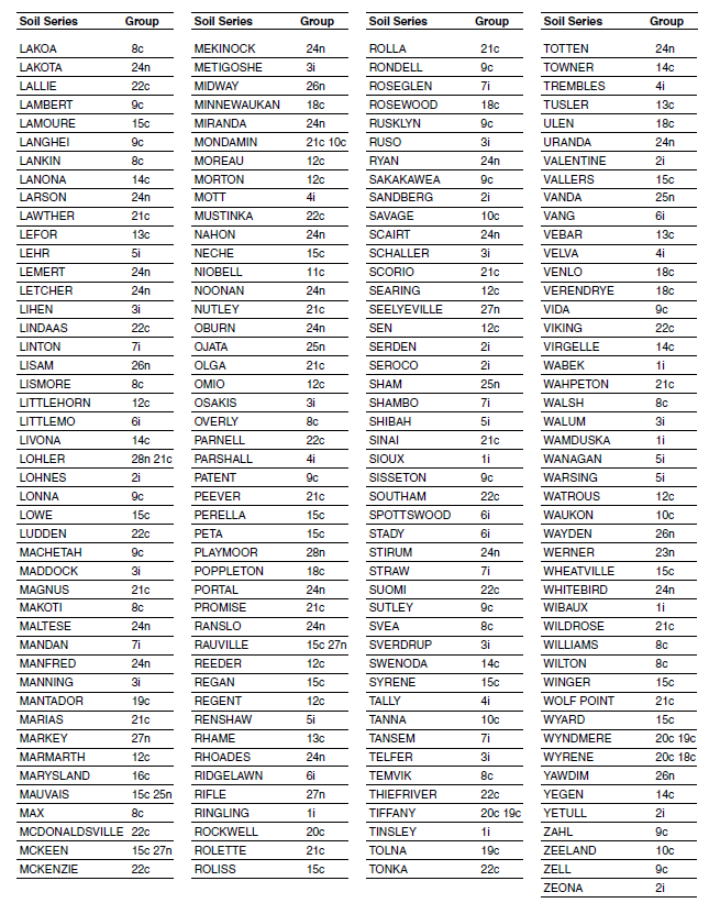
Soil Texture Abbreviations
Abbreviations for soil texture, from coarse to fine, used in this publication:
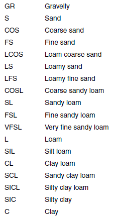
Irrigability Groups
In the following text,
< = less than
> = greater than
dS/m = deciSiemens per meter
EC = electrical conductivity
SAR = sodium absorption ratio
Irrigable Soils (i)
Irrigable soils generally require less management than conditional soils. Even though the soils are in an irrigable class, good irrigation management is essential. Attention to the allowable irrigation water quality is important. The use of lower-quality water than recommended can lower the productivity of the soils from salts and sodium. Different phases of each soil series may modify irrigation recommendations.
1i. Brandenburg, Coe, Kirby, Ringling, Sioux, Tinsley, Wabek, Wamduska, Wibaux
Drainage: excessively drained
Surface texture: L, SL
Substratum texture: sand and gravel
Surface intake rate for sprinkler irrigation: 0.5-0.7 inch/hour for slopes < 6 percent
Limiting permeability within 40 inches: 0.6 to 2 inches/hour in the upper part and > 6 inches/hour in the lower part
Profile characteristics: shallow/very shallow (< 20 inches) to sand, gravel and porcellanite (scoria)
Depth to lime: 0-10 inches
Surface pH: 6.6-8.4
EC (maximum within 40 inches in dS/m): 0
SAR (maximum within 40 inches): 0
Water-holding Capacity (rounded to the nearest 0.5 inch; on-site values may vary)
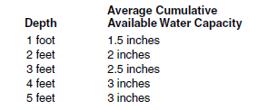
Water Management Practicesa
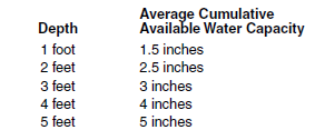
Water management on these soils is critical because of low available water capacity and nutrient leaching hazard.
2i. Aylmer, Banks, Blanchard, Claire, Falsen, Flaming, Lohnes, Sandberg, Serden, Seroco, Valentine, Yetull, Zeona
Drainage: moderately well to excessively drained
Surface texture: CoS, S, FS, LCoS, LS, LFS, CoSL, SL, FSL
Subsoil texture: FS, S, LCoS, CoS
Surface intake rate for sprinkler irrigation: 0.5->1 inch/hour for slopes < 9 percent
Limiting permeability within 40 inches: 6-20 inches/hour
Profile characteristics: sandy and moderately coarse-textured material
Depth to lime: 10-30 inches
Surface pH: 6.1-7.3
EC (maximum within 40 inches in dS/m): 0
SAR (maximum within 40 inches): 0
Water-holding Capacity (rounded to the nearest 0.5 inch; on-site values may vary)
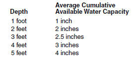
Maximum allowable EC < 3 dS/m; maximum allowable SAR <12
Water Management Practices
Water management on these soils is critical because of low available water-holding capacity and nutrient leaching hazard.
3i. Appam, Arvilla, Binford, Clontarf, Cozberg, Hanly, Hecla, Hilaire, Lihen, Maddock, Manning, Metigoshe, Osakis, Ruso, Schaller, Sverdrup, Telfer, Walum
Drainage: moderately well to somewhat excessively drained
Surface texture: FSL, SL, CoSL, LFS, LS
Subsoil and substratum texture: SL and L in the upper part and LS to sand and gravel in the lower part
Surface intake rate for sprinkler irrigation: 0.4-1.5 inches/hour for slopes < 6 percent
Limiting permeability within 40 inches: 2-20 inches/hour in the upper part and > 6 inches/hour in the lower part
Profile characteristics: moderately coarse and medium-textured material in the upper part and coarse-textured material in the lower part
Depth to lime: 10-30 inches
Surface pH: 6.1-7.8
EC (maximum within 40 inches in dS/m): 0
SAR (maximum within 40 inches): 0
Water-holding Capacity (rounded to the nearest 0.5 inch; on-site values may vary)
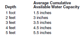
Maximum allowable EC < 3 dS/m; maximum allowable SAR <12
Water Management Practices
An irrigation scheduling system must be used.
4i. Breien, Chinook, Egland, Embden, Glendive, Inkster, Mott, Parshall, Tally, Trembles, Velva
Drainage: well and moderately well drained
Surface texture: SL, FSL, L
Subsoil texture: SL, FSL, L
Surface intake rate for sprinkler irrigation: .5-1 inch/hour for slopes < 6 percent
Limiting permeability within 40 inches: 0.6-6 inches/hour
Profile characteristics: moderately coarse and medium-textured material
Depth to lime: 10-20 inches
Surface pH: 6.1-8.4
EC (maximum within 40 inches in dS/m): 0-2
SAR (maximum within 40 inches): 0
Water-holding Capacity (rounded to the nearest 0.5 inch; on-site values may vary)
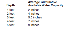
Maximum allowable EC < 3 dS/m; maximum allowable SAR <12
Water Management Practices
An irrigation scheduling system must be used.
5i. Baahish, Brantford, Hidatsa, Kensal, Lehr, Renshaw, Shibah, Wanagan, Warsing
Drainage: well and moderately well drained
Surface texture: SL, L
Substratum texture: 2C material is GrSL to sand and gravel
Surface intake rate for sprinkler irrigation: 0.5-0.7 inch/hour for slopes < 6 percent
Permeability within 40 inches: 0.6-2 inches/hour in the upper part and > 6 inches/hour in the lower part
Profile characteristics: moderately coarse and medium-textured material over sand and gravel that is shallow to moderately deep (< 40 inches)
Depth to lime: 10-20 inches
Surface pH: 6.1-7.8
EC (maximum within 40 inches in dS/m): 0 to 1
SAR (maximum within 40 inches): 0
Water-holding Capacity (rounded to the nearest 0.5 inch; on-site values may vary)
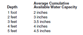
Maximum allowable EC < 3 dS/m; maximum allowable SAR <9
Water Management Practices
An irrigation scheduling system must be used.
6i. Bowdle, Brisbane, Bulltop, Chanta, Fordville, Littlemo, Ridgelawn, Spottswood, Stady, Vang
Drainage: moderately well and well drained
Surface texture: L, SIL, CL
Subsoil texture: L and CL in B horizons and GrL to GrS in the 2B or 2C horizons
Surface intake rate for sprinkler irrigation: 0.5-0.7 inch/hour for slopes < 6 percent
Limiting permeability within 40 inches: 0.6-2 inches/hour in the upper part and > 6 inches/hour in the lower part
Profile characteristics: moderately fine-textured material over moderately deep (20-40 inches) sand and gravel
Depth to lime: 15-30 inches
Surface pH: 6.1-7.3
EC (maximum within 40 inches in dS/m): 0-1
SAR (maximum within 40 inches): 0
Water-holding Capacity (rounded to the nearest 0.5 inch; on-site values may vary)
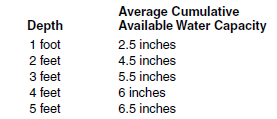
Maximum allowable EC < 3 dS/m: maximum allowable SAR < 9
Water Management Practices
An irrigation scheduling system must be used.
7i. Arnegard, Beotia, Eckman, Emrick, Gardena, Heimdal, Kremlin, Linton, Mandan, Roseglen, Shambo, Straw, Tansem
Drainage: moderately well and well drained
Surface textures: VFSL, SIL, L
Subsoil texture: VFSL, SIL, L, SICL
Surface intake rate for sprinkler irrigation: 0.1-0.5 inch/hour for slopes < 3 percent
Limiting permeability within 40 inches: 0.2-2 inches/hour
Profile characteristics: medium and moderately fine-textured material
Depth to lime: 15-30 inches
Surface pH: 6.6-7.8
EC (maximum within 40 inches in dS/m): 0-2
SAR (maximum within 40 inches): 0
Water-holding Capacity (rounded to the nearest 0.5 inch; on-site values may vary)
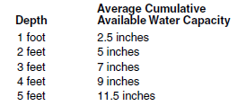
Maximum allowable EC < 2.25 dS/m; maximum allowable SAR < 6
Water Management Practices
An irrigation scheduling system must be used.
Conditional Soils (c)
Conditional soils can be irrigated under a high level of management. Soil conditions that contribute to conditional status are the presence of salts, poor drainage properties, the presence of subsurface layering, and the need for supplemental surface and subsurface drainage. Irrigation without high levels of management may degrade the soil quality for future generations but can be irrigated successfully if recommendations are followed. Soil phases of each soil series may modify irrigation recommendations.
8c. Aastad, Barnes, Bowbells, Bryant, Falkirk, Farland, Farnuf, Felor, Forman, Golva, Grassna, Great Bend, Hamlet, Korell, Kranzburg, La Prairie, LaDelle, Lakoa, Lankin, Lismore, Makoti, Max, Overly, Svea, Temvik, Walsh, Williams, Wilton
Drainage: moderately well to well drained
Surface texture: L, SIL, SICL
Subsoil texture: L, CL, SICL
Surface intake rate for sprinkler irrigation: 0.1-0.7 inch/hour for slopes < 3 percent
Limiting permeability within 40 inches: 0.2-2 inches/hour
Profile characteristics: medium and moderately fine-textured material
Depth to lime: 10-20 inches
Surface pH: 6.1-7.8
EC (maximum within 40 inches in dS/m): 0-4
SAR (maximum within 40 inches): < 2
Water-holding Capacity (rounded to the nearest 0.5 inch; on-site values may vary)
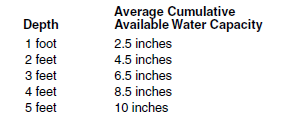
Maximum allowable EC < 1.5 dS/m; maximum allowable SAR < 6
Water Management Practices
These soils are conditional for irrigation due to moderate and moderately slow permeability and a potential for salinity increase in the subsoil. Salinity of the root zone should be monitored on a three- to five-year basis or more frequently if plant growth is restricted. Water, additional to that used for crop production, may be required for leaching. Leaching should be done in the fall or early spring, when crop requirements for water are low. An irrigation scheduling system must be used.
9c. Balaton, Buse, Cherry, Esmond, Fairdale, Havre, Havrelon, Korchea, Lambert, Langhei, Lonna, Machetah, Patent, Rondell, Rusklyn, Sakakawea, Sisseton, Sutley, Vida, Zahl, Zell
Drainage: moderately well and well drained
Surface texture: VFSL, FSL, SL, L, SIL, CL, SICL 2/
Subsoil texture: L, SIL, CL, SICL
Surface intake rate for sprinkler irrigation: 0.5-0.7 inch/hour for slopes < 3 percent
Limiting permeability within 40 inches: 0.6-2 inches/hour
Profile characteristics: calcareous/medium and moderately fine-textured materials
Depth to lime: 0-10 inches
Surface pH: 6.6-8.4
EC (maximum within 40 inches in dS/m): < 4
SAR (maximum within 40 inches): < 2
Water-holding Capacity (rounded to the nearest 0.5 inch; on-site values may vary)
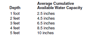
Maximum allowable EC < 1.8 dS/m; maximum allowable SAR < 6
Water Management Practices
These soils are conditional for irrigation due to moderate and moderately slow permeability and a potential for salinity increase in the subsoil. Salinity of the root zone should be monitored on a three- to five-year basis or more frequently if plant growth is restricted. Water, additional to that used for crop production, may be required for leaching. Leaching should be done in the fall or early spring, when crop requirements for water are low. An irrigation scheduling system must be used.
10c. Bearpaw, Bottineau, Croke, Ethridge, Grail, Kelvin, Mondamin, Savage, Tanna, Waukon, Zeeland
Drainage: moderately well and well drained
Surface texture: L, CL, SICL
Subsoil texture: CL, SICL, SIC, C (> 35 percent clay)
Surface intake rate for sprinkler irrigation: 0.1-0.5 inch/hour for slopes < 3 percent
Limiting permeability within 40 inches: 0.06-0.6 inch/hour
Profile characteristics: moderately fine to fine-textured material
Depth to lime: 15-40 inches
Surface pH: 6.1-7.8
EC (maximum within 40 inches in dS/m): < 4
SAR (maximum within 40 inches): < 4
Water-holding Capacity (rounded to the nearest 0.5 inch; on-site values may vary)
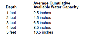
Maximum allowable EC < 1 dS/m; maximum allowable SAR < 6
Water Management Practices
These soils are conditional for irrigation due to moderately slow and slow permeability and a potential for salinity increase in the subsoil. Salinity of the root zone should be monitored on a three- to five-year basis or more frequently if plant growth is restricted. Water, additional to that used for crop production, may be required for leaching. Leaching should be done in the fall or early spring, when crop requirements for water are low. Subsurface drainage may be required for continued irrigation. An irrigation scheduling system must be used.
11c. Aberdeen, Alkabo, Belfield, Cathay, Cresbard, Niobell
Drainage: moderately well and well drained
Surface texture: L, SIL, SICL
Subsoil texture: CL, SICL (> 35 percent clay)
Surface intake rate for sprinkler irrigation: 0.1-0.7 inch/hour for slopes < 3 percent
Limiting permeability within 40 inches: 0.06-0.2 inch/hour
Profile characteristics: moderately fine and fine-textured material that have a degraded natric horizon within 20 inches
Depth to lime: 20-30 inches
Surface pH: 5.6-7.3
EC (maximum within 40 inches in dS/m): 2-8
SAR (maximum within 40 inches): 5-15
Water-holding Capacity (rounded to the nearest 0.5 inch; on-site values may vary)
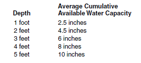
Maximum allowable EC < 1.5 dS/m; maximum allowable SAR < 4
Water Management Practices
These soils are marginal for irrigation, and irrigation of extensive areas should be avoided. Continued irrigation potentially could cause restricted water intake and permanent soil damage. Salinity of the root zone should be monitored on a three- to five-year basis or more frequently if plant growth is restricted. Water, additional to that used for crop production, may be required for leaching. Leaching should be done in the fall or early spring, when crop requirements for water are low. Subsurface drainage may be required for continued irrigation.
12c. Amor, Boxwell,Chama, Edgeley, Little Horn, Marmarth, Moreau, Morton, Omio, Reeder, Regent, Searing, Sen, Watrous
Drainage: well drained
Surface texture: L, SIL, SICL
Subsoil texture: L, SIL, SICL
Surface intake rate for sprinkler irrigation: 0.1-0.5 inch/hour for slopes < 3 percent
Limiting permeability within 40 inches: 0.0-0.6 inch/hour depending on texture of soft weathered bedrock
Profile characteristics: medium and moderately fine-textured materials moderately deep (20-40 inches) to soft weathered bedrock
Depth to lime: 10-20 inches
Surface pH: 6.1-7.8
EC (maximum within 40 inches in dS/m): 2-8
SAR (maximum within 40 inches): 0-4
Water-holding Capacity (rounded to the nearest 0.5 inch; on-site values may vary)
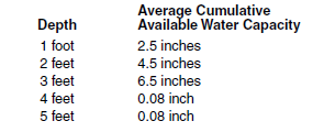
Irrigation Water Quality
Maximum allowable EC < 1.8 dS/m; maximum allowable SAR < 6
Water Management Practices
These soils are marginal for irrigation due to moderately deep (20-40 inches) bedrock and the potential for lateral seepage. Avoid irrigating extensive areas or where stratification is evident and seeps are present. Salinity monitoring should be done on a three- to five-year basis or more frequently if plant growth is restricted. An irrigation scheduling system must be used.
13c. Beisigl, Lefor, Rhame, Tusler, Vebar
Drainage: well to somewhat excessively drained
Surface texture: LS, LFS, SL, FSL
Subsoil texture: LS, LFS, SL, FSL
Surface intake rate for sprinkler irrigation: 0.5-1.5 inches/hour for slopes < 3 percent
Limiting permeability within 40 inches: 0.0-0.6 inch/hour
Profile characteristics: coarse and moderately coarse-textured material moderately deep (20-40 inches) to soft weather beds
Depth to lime: 10-20 inchesSurface pH: 6.1-7.8
EC (maximum within 4 inches in dS/m): 0
SAR (maximum within 40 inches): 0
Water-holding Capacity (rounded to the nearest 0.5 inch; on-site values may vary)
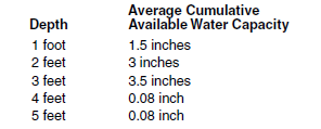
Maximum allowable EC < 1.8 dS/m; maximum allowable SAR < 6
Water Management Practices
These soils are marginal for irrigation due to moderately deep (20-40 inches) bedrock and the potential for lateral seepage. Avoid irrigating extensive areas or where stratification is evident and seeps are present. Salinity monitoring should be done on a three- to five-year basis or more frequently if plant growth is restricted. An irrigation scheduling system must be used.
14c. Dickey, Flaxton, Krem, Lanona, Livona, Swenoda, Towner, Virgelle, Yegen
Drainage: moderately well and well drained
Surface texture: LS, LFS, SL, FSL
Subsoil texture: L, CL, SICL
Surface intake rate for sprinkler irrigation: 0.5-1.5 inches/hour for slopes < 3 percent
Limiting permeability within 40 inches: 0.2-0.6 inch/hour
Profile characteristics: coarse-textured material over medium and moderately fine-textured material
Depth to lime: > 15 inches
Surface pH: 6.1-7.3
EC (maximum within 40 inches in dS/m): 0-4
SAR (maximum within 40 inches): < 2
Water-holding Capacity (rounded to the nearest 0.5 inch; on-site values may vary)
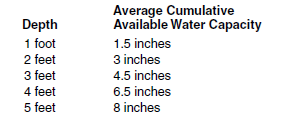
Maximum allowable EC < 1.8 dS/m; maximum allowable SAR < 9
Water Management Practices
These soils are conditional for irrigation due to the subsoil’s moderately slow permeability and potential for increased salinity. Salinity in the root zone should be monitored on a three- to five-year basis or more frequently if plant growth is restricted. Water, additional to that used for crop production, may be required for leaching. Leaching should be done in the fall or early spring, when crop requirements for water are low. An irrigation scheduling system must be used.
15c. Antler, Augsberg, Bearden, Bigsandy, Cashel, Colvin, Doran, Flom, Galchutt, Gilby, Hamerly, LaMoure, Lowe, McKeen, Neche, Perella, Rauville, Regan, Roliss, Styrene, Vallers, Wheatville, Winger, Wyard
Drainage: somewhat poorly and poorly drained
Surface texture: L, SIL, SICL, SIC, C
Subsoil texture: L, SIL, SICL, SIC, C
Surface intake rate for sprinkler irrigation: 0.1-0.7 inch/hour for slopes < 3 percent
Limiting permeability within 40 inches: 0.2-0.6 inch/hour
Profile characteristics: medium to fine-textured materials
Depth to lime: 0-10 inches
Surface pH: 6.6-8.4
EC (maximum within 40 inches in dS/m): < 6
SAR (maximum within 40 inches): < 3
Water-holding Capacity (rounded to the nearest 0.5 inch; on-site values may vary)
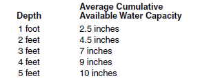
Maximum allowable EC < 1.5 dS/m; maximum allowable SAR < 6
Water Management Practices
Irrigate only if adequate surface and subsurface drainage has been provided. Salinity of the root zone should be monitored on a three- to five-year basis or more frequently if plant growth is restricted. An irrigation scheduling system must be used.
16c. Divide, Marysland
Drainage: somewhat poorly and poorly drained
Surface texture: L, CL, SIL
Subsoil texture: L, CL
Surface intake rate for sprinkler irrigation: 0.1-0.5 inch/hour for slopes < 3 percent
Limiting permeability within 40 inches: 0.6-2 inches/hour in the upper part and > 6 inches/hour in the lower part
Profile characteristics: Aeric and Typic Calciaquolls, medium and moderately fine-textured material over sand and gravel
Depth to lime: 0-10 inches
Surface pH: 7.4-8.4
EC (maximum within 40 inches in dS/m): < 2
SAR (maximum within 40 inches): 0
Water-holding Capacity (rounded to the nearest 0.5 inch; on-site values may vary)
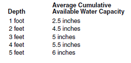
Maximum allowable EC < 3 dS/m; maximum allowable SAR < 9
Water Management Practices
Irrigate only if adequate surface and subsurface drainage has been provided. Salinity of the root zone should be monitored on a three- to five-year basis or more frequently if plant growth is restricted. An irrigation scheduling system must be used.
17c. Bohnsack, Borup, Elmville, Fram, Glyndon
Drainage: somewhat poorly and poorly drained
Surface texture: FSL, SIL, L
Subsoil texture: FSL, SIL, L
Surface intake rate for sprinkler irrigation: 0.5-1 inch/hour for slopes < 3 percent
Limiting permeability within 40 inches: 0.6-2 inches/hour
Profile characteristics: Aeric and Typic Calciaquolls, moderately coarse and medium-textured material
Depth to lime: 0-10 inches
Surface pH: 7.4-8.4
EC (maximum within 40 inches in dS/m): < 6
SAR (maximum within 40 inches): 0-1
Water-holding Capacity (rounded to the nearest 0.5 inch; on-site values may vary)
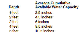
Maximum allowable EC < 2.25 dS/m; maximum allowable SAR < 6
Water Management Practices
Irrigate only if adequate surface and subsurface drainage has been provided. Salinity of the root zone should be monitored on a three- to five-year basis or more frequently if plant growth is restricted. An irrigation scheduling system must be used.
18c. Banks (variant), Bantry, Cormant, Fossum, Garborg, Hamar, Karlsruhe, Minnewaukan, Poppleton, Rosewood, Ulen, Venlo, Verendrye, Wyrene
Drainage: somewhat poorly and poorly drained
Surface texture: CoSL, LFS, LS, FS, S
Subsoil texture: LFS, LS, S, FS
Surface intake rate for sprinkler irrigation: 0.5-1.5 inches/hour for slopes < 3 percent
Limiting permeability within 40 inches: 2-20 inches/hour
Profile characteristics: coarse and moderately coarse-textured material
Depth to lime: 0-30 inches
Surface pH: 6.1-8.4
EC (maximum within 40 inches in dS/m): 0-2
SAR (maximum within 40 inches): 0-1
Water-holding Capacity (rounded to the nearest 0.5 inch; on-site values may vary)
Irrigation Water Quality
Maximum allowable EC < 3 dS/m; maximum allowable SAR < 12
Water Management Practices
Irrigate only if adequate surface and subsurface drainage has been provided. Salinity of the root zone should be monitored on a three- to five-year basis or more frequently if plant growth is restricted. An irrigation scheduling system must be used.
19c. Arveson, Delamere, Fossum, Galatin, Mantador, Tiffany, Tolna, Wyndmere, Wyrene
Drainage: somewhat poorly and poorly drained
Surface texture: VFSL, FSL, SL
Subsoil texture: VFSL, FSL, SL
Surface intake rate for sprinkler irrigation: 0.5-1.25 inches/hour for slopes < 3 percent
Limiting permeability within 40 inches: 2-6 inches/hour
Profile characteristics: moderately coarse and medium-textured material
Depth to lime: Calciaquolls 0-10 inches, Aquolls > 20 inches
Surface pH: 6.1-8.4
EC (maximum within 40 inches in dS/m): 0-2
SAR (maximum within 40 inches): 0-1
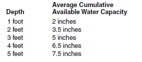
Water-holding Capacity (rounded to the nearest 0.5 inch; on-site values may vary)
Maximum allowable EC < 3 dS/m; maximum allowable SAR < 12
Water Management Practices
Irrigate only if adequate surface and subsurface drainage has been provided. Salinity of the root zone should be monitored on a three- to five-year basis or more frequently if plant growth is restricted. An irrigation scheduling system must be used.
20c. Espelie, Grimstad, Kratka, Rockwell, Tiffany, Wyndmere
Drainage: somewhat poorly and poorly drained
Surface texture: L, FSL, SL, LFS, LS
Subsoil texture: SL, SIL, L, CL
Surface intake rate for sprinkler irrigation: 0.5-1.5 inches/hour for slopes < 3 percent
Limiting permeability within 40 inches: 0.2-2 inches/hour
Profile characteristics: coarse and moderately coarse-textured material over medium-textured material
Depth to lime: 0 -10 Inches
Surface pH: 7.4-8.4
EC (maximum within 40 inches in dS/m): < 4
SAR (maximum within 40 inches): < 2
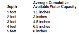
Water-holding Capacity (rounded to the nearest 0.5 inch; on-site values may vary)
Maximum allowable EC < 1.8 dS/; maximum allowable SAR < 9
Water Management Practices
Irrigate only if adequate surface and subsurface drainage has been provided. Salinity of the root zone should be monitored on a three- to five-year basis or more frequently if plant growth is restricted. An irrigation scheduling system must be used.
21c. Gwinner, Hattie, Hoffmanville, Lawther, Lohler, Magnus, Marias, Nutley, Olga, Peever, Promise, Rolette, Rolla, Scorio, Sinai, Wahpeton, Wildrose, Wolf Point
Drainage: moderately well and well drained
Surface texture: SIC, C
Subsoil texture: SIC, C
Surface intake rate for sprinkler irrigation: 0.1-0.2 inch/hour for slopes < 3 percent
Limiting permeability within 40 inches: 0.06-0.2 inch/hour
Profile characteristics: fine-textured material
Depth to lime: 0-20 inches
Surface pH: 7.3-8.4
EC (maximum within 40 inches in dS/m): 1-4
SAR (maximum within 40 inches): 0-1
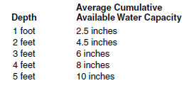
Water-holding Capacity (rounded to the nearest 0.5 inch; on-site values may vary)
Maximum allowable EC < 1 dS/m; maximum allowable SAR < 6
Water Management Practices
These soils are conditional for irrigation due to moderately slow and slow permeability and a potential for salinity increase in the subsoil. Salinity of the root zone should be monitored on a three- to five-year basis or more frequently if plant growth is restricted. Water, additional to that used for crop production, may be required for leaching. Leaching should be done in the fall or early spring, when crop requirements for water are low. Subsurface drainage may be required for continued irrigation. An irrigation scheduling system must be used.
22c. Dimmick, Dovray, Enloe, Fargo, Fulda, Grano, Hegne, Lallie, Lindaas, Ludden, McDonaldsville, McKenzie, Parnell, Southam, Suomi, Thiefriver, Tonka, Viking
Drainage: poorly drained and drained phases of poorly and very poorly drained
Surface texture: L, SIL, SICL, SIC, C
Subsoil texture: SIC, C
Surface intake rate for sprinkler irrigation: 0.1-0.4 inch/hour for slopes < 3 percent
Limiting permeability within 40 inches: 0.06-0.2 inch/hour
Profile characteristics: medium to fine-textured material in the upper part and fine-textured material in lower part
Depth to lime: 0 > 40 inches
Surface pH: 6.1-8.4
EC (maximum within 40 inches in dS/m): < 4
SAR (maximum within 40 inches): 0
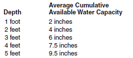
Water-holding Capacity (rounded to the nearest 0.5 inch; on-site values may vary)
Irrigation Water Quality
Maximum allowable EC < 1 dS/m; maximum allowable SAR < 6
Water Management Practices
These soils are conditional for irrigation due to slow permeability, wetness and a potential for salinity increase. Salinity of the root zone should be monitored on a three- to five-year basis or more frequently if plant growth is restricted. Water, additional to that used for crop production, may be required for leaching. Leaching should be done in the fall or early spring, when crop requirements for water are low. An irrigation scheduling system must be used.
Nonirrigable (n)
These are soils with very severe limitations to irrigation because of one or more of the following: slope, sodicity, salinity, excessively slow permeability, root restrictive subsoil layering. Irrigation is strongly discouraged. Irrigation will cause soil quality to be degraded and reduce the productivity of the soils for future generations of farm producers. Different phases of each soil series will modify irrigation recommendations.
23n. Nonirrigable because of relief (slopes > 6 percent), depth or root restrictive substrata
Arikara, Buse, Cabba, Cohagen, Dumps, Dune Land, Flasher, Sioux, Werner
24n. Nonirrigable because of relief (slopes > 6 percent), sodicity (SAR > 13 within 40 inches), salinity (EC > 4 dS/m), slow or very slow permeability, or root restrictive subsoil
Absher, Barkof, Beckton, Cavour, Daglum, Desart, Dogtooth, Ekalaka, Evridge, Exline, Ferney, Gerda, Harriet, Heil, Hoven, Janesburg, Ladner, Lakota, Larson, Lemert, Letcher, Maltese, Manfred, Mekinock, Miranda, Nahon, Noonan, Oburn, Portal, Ranslo, Rhoades, Ryan, Scairt, Stirum, Totten, Uranda, Whitebird
25n. Nonirrigable because of salinity (EC > 8 dS/m) and slopes < 6 percent
Antler, Arnegard, Arveson, Bearden, Belfield, Benz, Borup, Colvin, Divide, Easby, Elmville, Ojata, Fargo, Fossum, Fram, Gilby, Glyndon, Grano, Grassna, Hamerly, Hegne, Ladelle, Lallie, LaMoure, Lohler, Ludden, Mandador, Moreau, Ojata, Overly, Parshall, Patent, Playmoor, Regan, Savage, Scorio, Sham, Vallers, Vanda, Velva, Wyndmere.
These soils may be classified in other groups without salinity.
26n. Nonirrigable due to shallow depth of root restrictive substrata (slopes < 6 percent)
Bainville, Cabba, Cabbart, Cedarpan, Dilts, Duncom, Dupree, Farfeld, Fleak, Kloten, Lisam, Midway, Wayden, Yawdim
27n. Nonirrigable because of seasonal or semipermanant ponding. Slopes < 1 percent
Very poorly drained Arveson, Borup, Colvin, Dimmick, Fargo, Fossum, Hegne, Lallie, Ludden, Marysland, McKeen, Neche, Parnell, Rauville, Regan, Roliss, Rosewood, Southam, Venlo.
Peat and Muck soils: Eramosh, Markey, Rifle, Seelyeville.
These soils may be classified in other groups but are poorly drained.
28n. Nonirrigable because of frequent flooding (> 50 percent chance of flooding)
Banks, Breien, Cashel, Colvin, Divide, Fairdale, Glendive, Hanly, Havre, Havrelon, Korchea, Korell, La Prairie, LaDelle, Lallie, LaMoure, Lohler, Ludden, Magnus, Marysland, Minnewaukan, Neche, Ojata, Patent, Playmoor, Rauville, Regan, Rhoades, Scorio, Straw, Svea and Trembles, Velva, Wolfpoint.
These soils may be classified in other groups with a lower chance of flooding.
29n. NonIrrigable due to numerous surface stones or boulders
Amor, Barnes, Beisigl, Boxwell, Buse, Cabba, Cabbart, Forman, Marmarth, Max, Morton, Reeder, Ringling, Sioux, Svea, Vallers, Vebar, Wabek, Wamduska, Williams, Zahl.
These soils may be classified in other groups because they have less surface stones.
Important Topographic and Soil Properties Affecting Irrigability
Soil Depth
Soil depth depends on the potential rooting depth of the plants to be grown and any restrictions within the soil that may hinder root growth. The rooting depth of potatoes may be only 18 to 24 inches, while alfalfa has a rooting depth of more than 4 feet. Discontinuities in the soil from layers of sand, gravel or bedrock may serve to physically limit the depth of root penetration.
Soil Texture
The percentage of sand-, silt- and clay-sized particles determines the texture. Texture influences other properties, such as water-holding capacity, infiltration rate and internal drainage.
Soil Structure
Movement of water into and within soils is partially dependent on soil structure. Soil structure refers to how sand, silt and clay particles are arranged in the soil. Particles aggregate via organic matter and associated biological activity, roots, soil mineral composition, freeze-thaw cycles, wet-dry cycles and time. Outside forces can impact aggregation and soil structure, such as compaction. Soils containing aggregates are unstable under irrigation and may require special management.
Water-holding Capacity
Water-holding capacity is defined as the soil water retained between a suction of 0.1 to 0.5 bars (field capacity) and 15 bars (permanent wilting point). Water held between these two suction values is regarded as plant-available water. A silt loam soil holds about 2.25 to 2.5 inches of water per foot of soil. A sandy loam can hold only about 1 inch of water per foot. Soil with high organic matter can hold more water than a soil with similar texture and lower organic matter.
Slope
Slope is important in determining the runoff potential of water from a field. Water and soil losses from runoff reduce short-term and long-term economic returns. Generally, more runoff will occur on fine-textured soils, compared with coarser-textured soils on similar slopes.
Infiltration Rate (also called intake rate)
The infiltration rate is the relative rate that water penetrates and moves into the soil after a rain or irrigation event. The rate of infiltration is dependent on soil texture and structure but primarily is controlled by the surface conditions such as slope, roughness, residue and soil moisture. At the beginning of a rain or irrigation event, a dry soil surface will absorb more water than a wet surface, thus affecting the amount of potential runoff. A faster infiltration rate allows less runoff than soil with slower rates.
Internal Drainage
Internal drainage describes the degree and persistence of soil wetness and is influenced by slope, soil infiltration rate, soil texture (percent gravel, sand, silt and clay) and depth to the water table or impermeable layers. Excessively drained soils often have crop production problems related to lack of water and nutrients due to rapid movement of water through the soil profile. On the other hand, soils with poor internal drainage that remain wet may increase disease potential to crops, or cause denitrification losses of nitrogen fertilizer or the accumulation of salts. Soils with good internal drainage respond well to irrigation. Soil retains irrigation water for crops to use while allowing sufficient movement of water within the soil to minimize saturation of pore space.
Salinity
High levels of soluble salts at or near the surface usually are the result of a high water table but also can accumulate through the years from dissolved salts in the irrigation water. High salt levels may reduce crop yields and increase the water requirement of plants. Irrigation may decrease the depth to the water table through time in some soils, thus increasing the risk of salinization. As salinity increases, crop productivity will decrease. Salinity is a soil property that changes relatively quickly with time, compared with other properties such as texture. Soil testing for salts is necessary to not only follow possible increases through time in irrigated fields but also determine if irrigation should be attempted in the first place.
Salts are detected by measuring the flow of electrical current through a sample of soil or water. The more salts in a sample, the less resistance to electrical current and greater the electrical conductivity.
Sodicity (sodium buildup in soil)
Sodium (Na) affects the physical condition of the soil by dispersing soil aggregates. The soil becomes pasty when wet and develops a condition called “puddling,” where water remains on the surface for an extended period. The soil becomes hard when dry and its permeability to water and air is reduced.
If irrigation causes sodium salts to accumulate near the soil surface, yields may be reduced. Sodium buildup usually occurs slowly and may not be detected easily from year to year. Excess sodium accumulation in the root zone is a major threat to good productivity on some soils. Include the sodium absorption ratio in your regular soil testing checklist every three to five years to determine long-term trends in sodium accumulation.
Quality of Irrigation Water
The quality of some water sources is not suitable for irrigating crops. Irrigation water must be compatible with the crops and soils to which it will be applied. The Soil and Water Environment Laboratory at NDSU provides soil water compatibility analysis and recommendations for irrigation. Lab personnel need an analysis of the water to be used for irrigation and a legal description of the land to make a recommendation.
Salinity and Sodicity of Irrigation Water
The salt (or mineral) content of irrigation water is important for the long-term irrigability of many soils. Irrigation water with large concentrations of salts, when applied to the soil, increases the salt content in the soil because the water is taken up by the plant or evaporates while the salt remains.
To determine the salt content in water, measure the flow of electrical current through a sample of the water. The more dissolved minerals in the water sample, the more easily it conducts electricity, which produces a high electrical conductivity (EC) number.
Distilled water has very high resistance and thus a very low EC, but when the salt content increases, the resistance decreases. The EC has units of deci-Siemens per meter (dS/m), millimhos per centimeter (mmhos/cm) or micromhos per centimeter (umhos/cm).
Here is how to convert from one to the others:
1 dS/m = 1 mmho/cm = 1,000 umhos/cm
The sodium level in the soil in relation to the calcium and magnesium, as well as sodium content in the irrigation water, are important for the long-term productivity and health of the soil. The use of high-sodium water for irrigation depends on the level of salinity (EC) and sodicity in the soil and water.
The measure of the sodium impact is the sodium absorption ratio (SAR), whose units are dimensionless. It is the ratio of sodium concentration to the concentration of calcium and magnesium in soil or water. Generally, soil and water with SARs of less than 6 are acceptable.
Countering Sodium Buildup From the Use of High-SAR Irrigation Water
The sodicity buildup hazard for irrigation water is dependent on its SAR and salinity. As the salt content of the water increases, the sodicity hazard also increases. This means that lower SARs may cause significant sodium buildup in the soil. The reason for increased sodicity hazard is simply the greater number of sodium ions to replace calcium and magnesium in the soil.
The laboratory-derived SAR may not be a clear indicator of the actual dispersion of clay particles due to increased sodium levels or decreased soluble calcium and magnesium in a soil. A quick field test of suspected areas may help. Place ½ cup of surface soil in a clear glass quart jar, add 1 pint of distilled water and shake well. Leave for an hour undisturbed. If the water has not cleared in that time, the clay has become dispersed and an amendment may need to be applied to keep the surface soil productive.
Calcium Amendments for Soil and Irrigation Water
Sodium accumulation and clay dispersion may be countered by the addition of soluble calcium amendments that replace more weakly held sodium on clay and organic-matter surfaces and increase flocculation (clay particles aggregate into clotlike masses or precipitate into small lumps). Free sodium then can be leached from the soil surface to below the root zone, where it will not interfere with plant growth.
Gypsum, which is the common name for calcium sulfate (CaSO4), has been used successfully as a reclamation amendment when the soil was not already saturated with gypsum. In areas with low soil salt content, gypsum is the preferred method of reclaiming high-sodium soils.
Gypsum dissolves in the soil, and calcium ions replace sodium ions on clay and organic-matter surfaces. Water moving through the soil then leaches the sodium out of the root zone.
However, in many North Dakota soils, sodium and calcium levels are high together. The addition of gypsum to soils already high in gypsum will not result in a replacement of sodium because greater amounts of gypsum will not increase the number of free calcium ions in solution. Other amendments may be more useful.
For soils with high levels of calcium carbonate and low levels of gypsum, the application of elemental sulfur sometimes is used to produce gypsum. Sulfur is oxidized in soils by sulfur bacteria. The resulting sulfuric acid reacts with calcium carbonate to produce gypsum.
On a few soil series, subsurface gypsum layers can be incorporated into surface soils with high sodium levels through deep tillage. Mixing gypsum into high-sodium soils may be a practical way to reclaim some soils.
Before tillage, soil sampling surface and deep layers with for sodium and gypsum levels will be necessary. If excess gypsum is not present in the subsurface layers, deep tillage may not be helpful.
More soluble calcium amendments, such as calcium chloride, may be more useful in replacing sodium ions in sulfatic systems. Calcium chloride is more soluble in sulfatic systems than gypsum.
The economics of reclamation and effectiveness of amendments in reclaiming sodic soils or countering sodium accumulation should be evaluated before deciding to use soluble calcium and magnesium amendments.
NDSU Soil and Water Testing Laboratory
701-231-8942
U.S. Mail:
North Dakota State University
Soil and Water Environment Laboratory
NDSU Dept. 7680
P.O. Box 6050
Fargo, ND 58108-6050
FedEx, UPS:
NDSU
103 Waldron Hall
1360 Bolley Drive
Fargo, ND 58102
References
Franzen, D. 2012, NDSU Extension publication SF1087, Managing Saline Soils in North Dakota.
U.S. Salinity Laboratory Staff. 1954. Diagnosis and improvement of saline and alkaline soils. Agricultural Handbook No. 60, U.S. Department of Agriculture, U.S. Government Printing Office, Washington D.C.
Irrigation Water Quality – Soil Compatibility Guidelines, 1987. Saskatchewan Water Corporation, Outlook, Canada.

Revised May 2018

