To Fly or Not to Fly: What Role do sUAS Play in Agriculture Today?
The role of small unmanned aerial systems (sUAS) in agriculture has garnered a mixed following over the last few years. Much of the work that has been done, and much of our understanding, has focused on research related projects, which is evident in the relatively large number of scientific journal articles that outline various uses from assessing crop health, to estimating above ground biomass. That said, the role that aerial imagery as a whole has had in agricultural and natural resource applications has long been seen as valuable. For example, the National Agricultural Imagery Program (NAIP) has been in existence since 2003 and represents a federal level program to collect imagery in the Red, Green, Blue, and Near-Infrared (NIR) portions of the electromagnetic spectrum (EMS). This brings us to one of the limiting factors of a typical “affordable” sUAS; the lack of a sensor capable of collecting in NIR, which has formed the basis of nearly all of our “traditional” vegetation index measures due to how NIR interacts with the leaf structure.
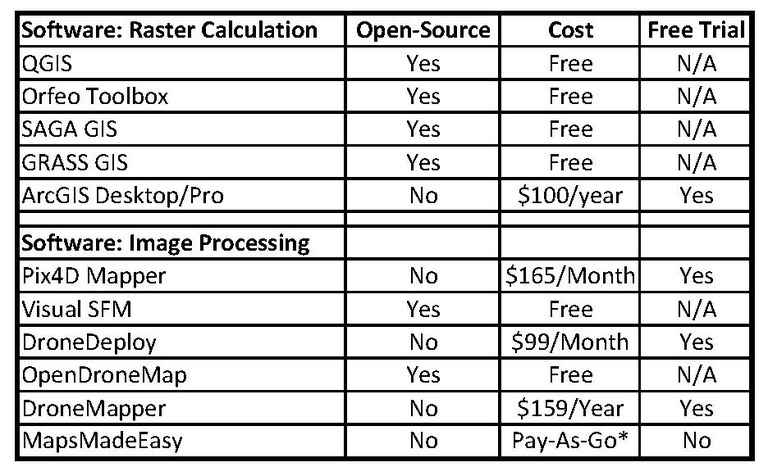
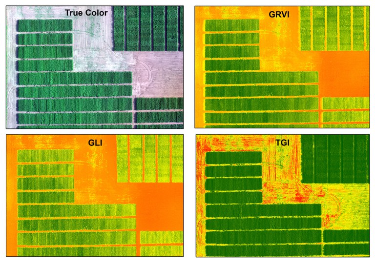
Notwithstanding the lack of NIR sensors, sUAS can provide valuable information with little up-front cost and much has been done to evaluate indexes that use only the visible portion of the EMS. The Green Leaf Index (GLI) was developed specifically for low-altitude crop applications (Figure 1), and others such as the Green-Red vegetation index (Figure 2), and the Triangular Greenness Index (TGI) (Figure 3) have found their place in agricultural applications. Another limiting factor has been the relatively short battery life (~20-30 minutes) for flights. However, with a maximum Federal Aviation Administration (FAA) altitude of 400’, a good deal of information can be collected in that 20-30-minute time span. In addition to the above issues, access to software to process the collected imagery also presents a hurdle. While there are any number of commercial applications out there, there are also low-cost/no-cost options to the average sUAS user for image processing and index calculations (Table 1).
Without question, sUAS have come a long way over the last 5-7 years. We are seeing more affordable airframes, with higher resolution cameras and longer battery life. We have seen advances in image processing algorithms and open source software. And we have seen an increase in interest surrounding non-NIR indexes as applied to agricultural problems. For those that currently have an sUAS, I would recommend getting it in the air! For those that don’t, it might be a worthwhile endeavor to explore what this technology has to offer; it will only get better as time moves forward. A sUAS isn’t the answer to every problem, but it can provide a plethora of information that can help drive decisions regarding nutrient application and prescription maps, and represents another tool in our agricultural toolbox.

Table 1: Sample listing of software available to calculate indexes, and to process imagery. Values range from free open source software, to commercial software at a cost. This table does not represent all of the options available, but rather those that the author has had direct interaction with. Many pay versions offer free trials. The prices listed for commercial software packages are generally considered “personal” use, as opposed to professional.

Figure 1: Three visible spectrum (non-NIR) indexes currently in use for agricultural purposes. Each index has its own strengths and weaknesses. The GLI was developed for low altitude monitoring, making it a good choice for a UAS. The GRVI is a variant of NDVI using the green portion of the EMS instead of the NIR portion. The TGI attempts to measure the reflected light that forms a triangle between the Red, Green, and Blue reflectance measures. The TGI is used to measure estimate leaf chlorophyll content, and has also been used to indirectly measure nitrogen content. All indexes were calculated from a standard RGB camera (e.g. standard camera on the Phantom 4 Pro) requiring no aftermarket costs or alterations.
David Kramar, Ph.D.
David.Kramar@ndsu.edu
Precision Agriculture Specialist


