Major Flooding Possible After Exceptional Drought
(Click the image below to view a high-resolution image that can be downloaded)
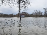
If you are wondering how a location can move from an exceptional drought to a major flood in a short period of time, you might want to watch the Red River Valley between North Dakota and Minnesota.
North Dakota suffered from a major drought in 2021 with an exceptional drought or a category four drought (D4) based on a scale from D0 to D4 with D4 being the most intense drought. All the counties in eastern North Dakota along the Red River Valley were rated at least D3 (or extreme drought) based on the drought monitor map published on August 24, 2021.
“Cass, Traill and Grand Forks counties were even in worse conditions with D4 or exceptional drought,” says Adnan Akyuz, state climatologist and professor of climatological practices at North Dakota State University (NDSU).
The 2021 drought was a record-breaking drought in many aspects. For instance, none of the counties mentioned above were in D4 prior to 2021. In fact, more than 17% of the state was suffering from an exceptional drought in 2021. It was the most extensive drought coverage in such intensity on record, and it was also the most extensive drought coverage in D3, D2 and D1 intensities on record.
“100% of the state was in drought 11 weeks in a row from June 15 through August 24,” says Akyuz.
The economic impact of the drought to the state was estimated between $2 billion to $5 billion based on the National Centers for Environmental Information.
“The weather patterns changed in August along the southern Valley,” says Akyuz.
October was unusually wet, not only along the Red River, but all across the state, which was a welcome change. However, it was too late to reverse the severe agricultural impact. It was also too early to foresee what might be in for the Red River Valley.
“Fargo’s climate data in fall and winter are good analogs to judge the flood potential in the southern valley” says Akyuz.
“Fargo received 7.31 inches of rain in fall, the 22nd wettest fall on record. Fargo also received 46.2 inches of snow so far in winter, which is the 20th snowiest winter on record, and the winter is not over in ND yet,” says Akyuz.
Based on the National Weather Service North Central River Forecast Center’s latest forecast, there is a 90% chance that the Red River will exceed the major flood stage this spring. The probability for exceeding the major flood stage in Grand Forks is only 25%.
“North Dakota climate has consistently demonstrated that extremes can occur in a very short period,” says Akyuz.
NDSU Agriculture Communication - March 3, 2022
Source: Adnan Akyuz, 701-231-6577, adnan.akyuz@ndsu.edu
Editor: Kristin Harner, 701-231-7875, kristin.harner@ndsu.edu


